

COG vs MrSID: A Surprising Geospatial Compression Test Result

Updated: Apr 22
Nowadays, the geospatial industry is managing larger raster datasets than ever before. Raster datasets are managed from aerial photography, satellite imagery, and orthophotography imagery, but it is necessary to get a balance between how much it costs to store them, how quickly they will perform, and how visually pleasing they are.
To compare the performance of the two widely used raster data storage formats, Cloud Optimized GeoTIFF (COG) and MrSID, we have conducted a side-by-side analysis. While this analysis provided some really interesting results, they were not what we expected.
Understanding the Technologies
First, before we delve into the detailed analysis of both formats, it is important to define what each format is to ensure the reader has a solid understanding of each format.
Cloud Optimized GeoTIFF (COG)
The Cloud Optimized GeoTIFF (COG) is a new raster file format that was developed to work with cloud-based applications, and allows for:
Efficient HTTP range requests
Quick access to small pieces of a large image
Seamless integration with cloud-based GIS applications
Although COGs are easy to stream and distribute, the overall sizes of the COG files are typically larger than other formats because they require tiling to maintain their overall structure.
What is MrSID?
The Multi-resolution Seamless Image Database (MrSID) is a Compression Technology using wavelet-based image compression algorithms specifically designed for raster image files. The MrSID format will:
Dramatically decrease the overall file size, with a very high level of visual quality
Allow for multi-resolution viewing, creating faster rendering times for the image

The Test: Comparing a COG Workflow to MrSID
We ran a simple but informative test:
Starting with a COG Dataset in a Cloud Optimized GeoTIFF
Generating a MrSID from the same source
Comparing file size, visual quality, and rendering consistency
Key Findings
Reduced file size
The original file was large as it was designed for optimized access versus significant compression, but significantly reduced in file size after converting the COG Dataset to a MrSID file with:
A tremendously smaller file size
No meaningful degradation in visual quality
Organizations with terabytes (or petabytes) of imagery will see this reduction in file size translate to lower data storage and efficient data transfer.
Improved visuals
This part of the test became interesting.
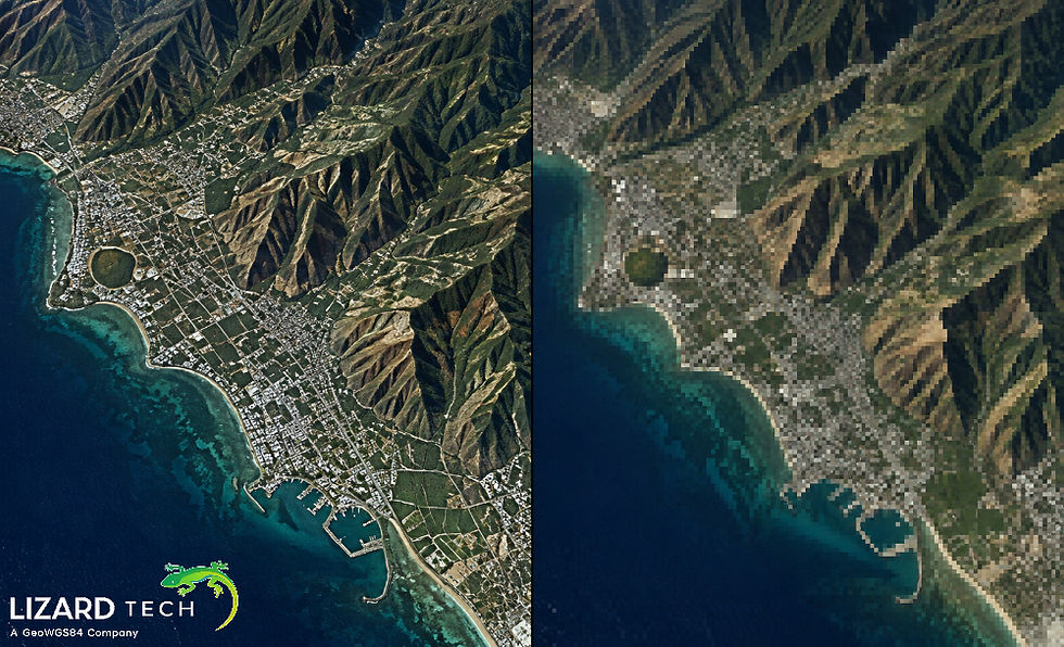
The source COG Dataset had visible seam artifacts, which may occur from:
Mosaicked imagery
Inconsistencies with tile boundaries
Cloud-optimized processes
The comparison of the two outputs from MrSID vs COG produced visually better results, as:
Seamless visualization
No visible seams
Continuity of images throughout the dataset
Although originating from the same source data, the MrSID created significant visual improvements over COG.
Improved Visualization Performance
MrSID's wavelet architecture permits efficient multi-resolution access, allowing for fast zooming and panning, less bandwidth usage, and smooth rendering of large data sets together.
This makes MrSID very suitable for high-performance visualization environments; these environments rely heavily on response time.
Why it matters for Geospatial Workflows
Companies that are managing large-volume geospatial image data have three primary objectives:
Minimize the storage footprint of their image data;
Keep the integrity of an image; and
Assure quick and reliable delivery of image data.
The test provides further evidence to support that compression technology still has a significant role even in cloud-first workflows.
Although COG has some advantages in the Cloud, MrSID has distinct advantages in the following areas:
Storage efficiency;
Visual consistency; and
High-performance rendering.
Key Takeaway
Smaller storage footprint, smoother visualization, and highly efficient delivery.
While the geospatial market evolves toward cloud-based solutions, it is important to keep in mind that choosing the "right" format is critical.
Advanced compression technologies like MrSID, based on Wavelet technology, are very effective when used for:
Large-scale image archive storage
Enterprise GIS system deployment
High-performance image visualization workflows
If your organization plans to use large raster datasets as part of its business workflow, then it may be time to reconsider how you use compression in its pipeline.
For more information or any questions regarding the LizardTech suite of products, please don't hesitate to contact us at:
Email: info@geowgs84.com
USA (HQ): (720) 702–4849
(A GeoWGS84 Corp Company)


Comments