

What Is Lossy Compression? How It Works, Benefits, and Use Cases

Updated: Aug 11
Geographic Information Systems (GIS) make extensive use of large amounts of spatial data obtained from satellites, drones, aerial surveys, and remote sensor technologies. Large files such as high-resolution images, raster data, and earth observation data can quickly become terabytes in size, creating difficulties with storage, data transfers, processing speed, and costs related to the cloud.
To solve this problem, GIS professionals use techniques for data compression that are small in size and high in usability. One widely implemented compression technology is lossy compression, where some of the data is removed instead of just reducing the data size, while not having a significant impact on interpretation and analysis.
Lossy compression differs from lossless compression in that lossless compression preserves all original values during data compression, while lossy compression intentionally removes some data to achieve a much larger reduction in size, making it extremely useful in the case of large raster images, satellite data, or aerial mapping.
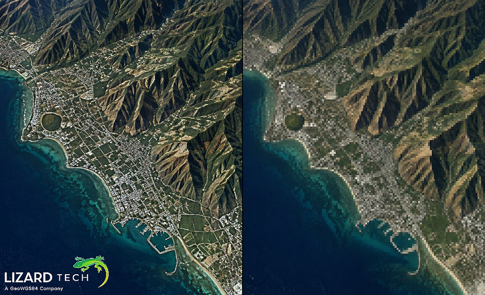
What Is Lossy Compression?
In the field of GIS, one of the methods used for data compression that minimizes the amount of data represented in spatial files is called lossy compression. In any case, it will not have a noticeable impact on the general quality of the data and spatial characteristics of the dataset.
Lossy compression is extensively utilized in the case of raster data, for example
aerial photography
remote sensing imagery
hypsometric map.
Lossy compression means analyzing an image in order to identify patterns and eliminating those that are redundant or do not have a significant meaning in the visual context. As a result, the data that are compressed take up less space.
In GIS, various compression technologies can be used:
JPEG
JPEG 2000
Enhanced Compression Wavelet
WebP
How Does Lossy Compression Work?
The principle behind lossy compression involves discerning and eliminating those pieces of information that play a lesser role in how people perceive images or the advancement of certain forms of visualizations. The steps involved in the compression process can be summarized as follows:
Analysis and conversion of data
The compression algorithm begins by processing the original raster dataset. Instead of storing each pixel's value separately, the algorithm applies several mathematical transformations to the dataset.
For example, in JPEG compression:
color space conversion
frequency transformation
spatial analysis
Wavelet-based formats, such as MrSID and JPEG2000, process images on different levels of resolution, enabling efficient storage and access capabilities.
Elimination of less relevant data
The compression algorithm detects less important pieces of information.
Examples of such data include:
insignificant color changes
repetitive patterns
invisible high-frequency details
negligible pixel differences
The removed information cannot be restored after decompression, which is why it is termed ‘lossy’.
Quantization
Quantization is the reduction of the precision of some data values.
For example,
Original image:
Pixel value: 152.734
Compressed image:
Pixel value: 153
This dispersion is negligible and usually invisible to anybody.
Encoding and Storage
After reducing unnecessary information, the remaining data is encoded into a smaller file structure.
The result is:
Smaller file size
Faster data access
Reduced storage requirements
Lossy Compression vs Lossless Compression in GIS
Feature | Lossy Compression | Lossless Compression |
Data preservation | Some information removed | All information preserved |
File size reduction | Very high | Moderate |
Image quality | Slight degradation possible | No quality loss |
Compression ratio | Higher | Lower |
Best for | Visualization and web mapping | Analysis and scientific processing |
Examples | JPEG, MrSID, ECW | GeoTIFF, PNG, TIFF |
Benefits of Lossy Compression in GIS
File Size Decrease of Significance
The major advantage of lossy compression is its power to reduce raster dataset sizes dramatically.
An aerial image of high resolution, which takes up to hundreds of gigabytes, can be compressed to a small fraction of its original size while maintaining an acceptable quality.
Decreasing the overall costs:
Lower expenses on storage
Faster backups process
Easier to share the data
Lowering expenses on the cloud.
Faster Data Transfer and Streaming
Transferring heavy GIS data can be problematic. Lossy compression solves this problem by minimizing the demands for bandwidth.
This is particularly important when it comes to:
Online GIS portals;
Web mapping applications;
Cloud geospatial technologies;
Distributing remote-sensing data.
The more compressed images are, the faster they load.
Enhanced GIS Functionality
Large raster data may hinder the performance of GIS technology. The advantages of compressed file formats are:
Faster display of images
Lower memory consumption
Increased map rendering speed
Bigger amount of data processed efficiently
For companies working with millions of images, compression provides a big advantage in productivity.
Efficient Cloud Storage
Modern geospatial systems process tons of geospatial information. Lossy compression helps organizations optimize:
Costs of object storage
Processing of data
Delivery of images
Cloud-based GIS systems practically always work with images using compressed raster formats.
Efficient Web Mapping
Fast image delivery is the basis for web maps. Lossy compression is used in:
Satellite image visualization
Drone mapping applications
Governmental mapping applications
Digital twin solutions
The efficient rendering of large datasets is made possible by formats like JPEG 2000, MrSID, and ECW.
Common GIS Use Cases of Lossy Compression
Managing Satellite Images
Satellite imaging sensors create enormous volumes of images constantly. To be able to store, process, and transmit the data efficiently, it needs to be compressed.
Applications of the technology can be found in:
Earth Observation
Environmental monitoring
Land cover classification
Disaster response
Use of lossy compression means organizations can keep large image databases while significantly reducing their operational costs.
Drone Mapping and Orthoprocessing
Drone surveys can produce high-resolution images. In just one flight, thousands of images and large sets of orthomosaics can be produced.
Lossy compression can be used to create:
RGB orthomosaics
Multispectral images
Inspection or monitoring images
Construction site maps
With the help of compression, there is quicker access to visual information.
Web GIS Applications
Web GIS applications need fast image retrieval and good performance.
Lossy compression brings:
Interactive maps
Web-based picture viewers
GIS dashboards
Location intelligence solutions
Users may explore vast territories without having to download huge volumes of data at once.
Digital Twins and Smart Cities
Smart city systems utilize a lot of geospatial data:
Aerial images
3D urban models
Infrastructure maps
Building information
Compression helps increase performance as it allows visualizing large cities more quickly.
Defense and Emergency Response Mapping
Large image datasets need instant access as organizations deal with emergencies.
With lossy compression, organizations can
Transfer images more quickly
Access mobile GIS
Visualize images in real-time
Share data effectively
Limitations of Lossy Compression
Despite the benefits of lossy compression, it may not work in all GIS processes.
Loss of Data Accuracy
Due to the loss of data, the compressed file may not be used for:
Scientific analyses
Accurate measurements
Classifications on a pixel level
Change detection studies
Compression Artifacts
Overcompression may lead to visible artifacts like:
Blurred images
Block patterns
Lower image sharpness
Choosing a proper compression rate is crucial!
Not Appropriate for Original Data Archives
Some organizations should have the original uncompressed or lossless compressed datasets for long-term storage and analysis...
Future of Lossy Compression in GIS
With the continual expansion of geospatial data, deploying effective compression systems is essential.
These future trends include:
AI-based image compression
Cloud-compatible raster formats
Compression powered by machine learning
Usage-based adaptive compression
Streaming of live imagery
New geospatial technologies are combining compression with cloud capability and artificial intelligence to give quicker access to vast Earth observation data.
Lossy compression in GIS can be a helpful method used to decrease the dimensions of large geospatial data while preserving enough quality needed for mapping and visualization purposes. Lossy compression can provide quicker access, lower storage costs, and better GIS performance as it discards less important data...
Such formats as JPEG 2000, MrSID, and ECW play an important role in very large satellite images, drone mapping images, aerial pictures, and GIS applications.
For more information or any questions regarding the LizardTech suite of products, please don't hesitate to contact us at:
Email: info@geowgs84.com
USA (HQ): (720) 702–4849
(A GeoWGS84 Corp Company)


Comments